For anyone interested in more photos, the public album from Facebook can be reached at:
http://www.facebook.com/media/set/?set=a.880046567589.2346241.12820170&l=8397a26732&type=1
Also, in case anyone on the trail is trying to find my blog based on my trail name, I should probably post that my trail name has been Scout's Honor (alternative misspellings may include Scouts Honor, Scout Honor, or just Scouts) for over a thousand miles. It's not a very exciting trail name, but it fits well enough and ought to do until a more exciting name (e.g., "Pants On Fire", "Grenade", etc.) comes along. Daybreaker and Easy Strider came up with it on our first day out of Kennedy Meadows since I had been bouncing scout-related names for several hundred miles prior. I left the McDonalds at Cajon Pass (Southern California, very early in the trip) with about seven other hikers. We ended up hitting a long series of switchbacks just as it was getting late and eventually camped together ON (I think my previous post from the time has a photo of all our tents lined up along the trail tread) the trail since there was nowhere else to go. Between cooking away from camp so as not to attract animals to my food at night, telling some of the other hikers not to through rocks as we were going up switchbacks while hikers were known to be below us, and a few other quips, the group agreed that a name related to scouts would be fitting. However, it took a while to come up with one since "Scout", "Boyscout", "Girlscout", and several others were already taken.
Sunday, August 28, 2011
Onwards Through Oregon
After packing down ridiculous amounts of food at the Etna brewery, I drove myself and a few of the other hikers back to the trailhead so that we could get a few miles in before sunset. I think I forgot to mention in my last post that just as I was arriving at the access point to Etna, a group of PCTA members pulled up to the trailhead to start a section hike. Kodak Karen recognized me as a thru-hiker and immediately offered her car keys to me on the condition that I drive PCT hikers back to the trail head when I returned. This was definitely one of the more interesting rides I have had into town. I was grateful to be entrusted with her car, but in hindsight it was a bit crazy on her part to just hand over the keys. Even if integrity was not a concern to her, I would have thought twice about giving the keys to a hiker who hasn't been behind a wheel for over three months - especially considering the road. The wide two-lane road at Etna Summit quickly turned into one of the windiest one-lane mountain roads that I have ever driven, and the car didn't exactly handle as smoothly as my Saturn Ion. Having my view obscured by the rising sun and a dusty windshield (wiper fluid was empty of course) added an extra bit of "excitement". Clearly I made it in and out of town safely though.
From Etna, it was about another two days until we hit the last trail town in CA: Seiad Valley. Passing through the small town of Seiad Valley, we quickly learned that there was actually one more state to pass through before we could enter Oregon: The State of Jefferson. Long-story-short, the rural counties in northern CA and southern OR have a history of feeling neglected by their larger state governments. In response, there was a fairly serious movement in the decades before WWII to gain autonomy by succeeding from their respective states and joining to form the 51st state (they even went as far as electing a governor). However, the movement lost steam when WWII fell into swing - yet the independent attitude of the area still remains. State of Jefferson seals were plastered everywhere, along with "NO K.S. MONUMENT!" signs. The latest ire to the locals is a proposal to designate much of the surrounding area, including the town of Seiad Valley, as a Klamath-Siskiyou National Monument. Although the proposal is being pushed by environmentalists in Ashland, the locals are STRONGLY against the plan. Granted I was party to very biased details since my main source of info was talking with the store clerk and campground manager, but my understanding is that a national monument designation would greatly hamper the town's land and water rights. Whatever the details, it is very clear that this town does not want to be messed with. Anyhow, I passed on the cafe's Five Pound Pancake Challenge and left early evening to make the 4,500' ascent back to the crest. The climb was pleasant considering we sat out the afternoon heat, but I was definitely looking forward to Oregon on account of its rumored flatness.


Oregon came soon enough and there was much rejoicing. After three months of heat, sun, cold, and snow, it felt great to finally make it out of CA! Before I left for this trip, I had never even backpacked over 100 miles - yet there I was with 1,700 miles down across an entire state. To make the celebration even better, our next resupply was the town of Ashland. Of all the towns that I've visited on the trail, Ashland is the one that I would most like to visit again in the future (preferably with a car). Between the great downtown area, a large city park, and a renowned Shakespeare festival, there was so much to see and do but too little time. I focused on resupplying and relaxing - thus I held back from wandering around and exploring everything that the town had to offer. While the hikers that were sharing my motel room went to a late-night play at the other end of town, I put in a solid 12 hours of sleep instead. So it was a good rest stop, but I have motivation for going back at some point.

From Ashland, the trail turned towards Crater Lake National Park. The trail also lived up to its reputation of being flat and soft - but it was not the land of milk and honey that I had been hoping for. To be honest, walking through a perfectly flat expanse of trees can get boring pretty quick. I like climbing, and I was soon longing to be up in the mountains again. Furthermore, there were mosquitoes. Lots of mosquitoes. Literary devices escape me for an accurate description of the horror (Gangsta Rap, Collin, and I have concluded that only creative sounds - not words - can come close). How an ecosystem can support that many blood-suckers is beyond my comprehension. From about two days out from Crater Lake to four days past the park, I was swarmed 24/7. I'm not keen on exposing myself to poison, but I finally broke down and began (sparingly) using DEET in the afternoons when it was too hot to ensconce myself in rain gear. Fortunately there were a few scenic gems floating throughout the mosquito hell-hole.
The first point of interest was Crater Lake. I thought Tahoe was amazing the first time I saw it, but Crater Lake blew me away. The dark and pure blue of the surface was mesmerizing, and the volcanic Wizard Island plus the rock walls combined to make one of the most surreal images of the trip. The PCT rides along the rim of Crater Lake for just over seven miles, and my timing worked out such that I got to split the traverse over two days. Although the rim is technically a no-camping zone, I figured that most of us PCT hikers are pretty good about Leave No Trace.


After Crater Lake, there was the jagged peak of Mt. Thielson and eventually exposed lava fields beneath The Sisters (prominent snow-covered peaks near the town of Sisters). Overall though, I pushed hard to get through this section as quickly as possible with a 38 mile day, a 35 mile day, and no days below 30 miles. I wanted OUT of the mosquitoes and I desperately needed to wash my clothes. How a single pair of socks can hold so much dirty is one of the trail mysteries that no one can seem to figure out, and my two pairs were typical. Despite my marginally-effective efforts to clean them on the trail, there was enough dirt in them that the arches of my feet were abraded to the point of needing band-aids and Neosporin for several days. On the bright side, I had good company between Crater Lake and Sisters. For the first few days I hiked off-and-on with Gangsta Rap and Collin, and I spent the last day or two around Rocklocks and Mr. Fox. The last night of hiking before I split to go into Sisters was particularly entertaining since Mr. Fox also has an engineering background. Getting two engineers in the same room together (or campsite) can be dangerous in that we will never shut up - and I reckon that everyone in camp lost a solid hour that could've been used to catch up on sleep. The main topic of conversation was devising outlandish ways to repel and/or kill mosquitoes (of course). After examining some less practical ideas such as a portable tesla coil (how would you power it?) and miniature laser turrets (same problem plus many more) - we started to think about acoustic methods. If you could acoustically force the mosquitoes at their resonant frequency - or the resonant frequency of their internal organs - that ought to freak them out enough to make them less interested in dinner (i.e., YOU). Of course that raises the question of "Well, how does one go about finding the resonant frequency of a mosquito?". After pondering the question, I laid out an experimental procedure that ought to work fairly well (to anyone associated with PETA or other animal rights groups, let me state that ethics does not apply to mosquitoes). I will spare you the details of super glue, shaker tables, and laser doppler vibrometers.


The only other interesting features from the last section were trail legends and trail magic. Right before the trail junction where many hikers go into Elk Lake Resort for a resupply, I ran into a blazing-fast Southbounder. He was the first thru-hiking Southbounder that I had encountered and he seemed to be in a hurry to push 12 more miles for the day. There was something familiar about him, as if I had seen a picture of him before, and he politely gave a detailed report of the trail conditions ahead in Washington. Granted things are changing quickly, so I should be better off by the time I get there, but he mentioned that he only had heavy snow north of Snoqualmie Pass. He had introduced himself as "Bink" and was carrying what looked to be the lightest/smallest pack I've seen yet. Only later when I got to town did I confirm that Bink was in fact Scott Williamson, a PCT legend. Scott Williamson holds the record for the fastest thru-hike at 66 days, and apparently he is trying to beat his previous record by making 65 days this year. Good luck to him; I'll be content just to finish the trail happy and healthy. As for trail magic, Lost and Found (a retired school teacher) was camped at Lava Lake and providing all sorts of delicious food to every hiker willing to make the half-mile detour.
From Lava Lake I had the option of catching a ride from the nearby McKenzie Pass or pushing on another 17 miles to Santiam Pass. Although I was craving a shower and clean clothes (trail magic had satiated my appetite somewhat), I wanted to knock a few miles off the next leg of my trip. I decided I would rather hike the extra 17 miles with a practically empty pack than have to carry any extra food out of Sisters. Santiam Pass proved to be the better hitch since there was actually a shoulder where cars could pull over and it was heavily traveled. I can't say that there's anything particularly interesting to report about Sisters, but it is a nice tourist town with everything (except canister fuel) that a thru-hiker could need. I intended to get a ton of sleep here, but I got sucked into watching both volumes of Kill Bill on AMC last night. Fortunately the coffee shop here has the best coffee I've seen on the trail yet. Anyhow, it looks like the afternoon rain has passed and it is about time that I get back to the trail. Next stop: Oregon-Washington border at Cascade Locks!
Thursday, August 11, 2011
Nor. Cal.
After taking what felt like an eternity to make it through the Sierras, Northern California has flown by in a blink of an eye. I am currently taking a much needed zero (my first for Northern California, although technically I still had to get up at 5 AM and hike 5 miles this morning) in Etna. Assuming things go right, this should be my last stop in California before I cross the border into Oregon! It's been a great adventure, but it is starting to wear on me that I've been hiking for exactly three months and am still in the same state as when I started. Fortunately the PCT holds a considerably straighter course through Oregon and Washington, so those states shouldn't take nearly as long (obviously the smaller size of the states helps as well).
For anyone interested in pictures, the public link for my Northern California album on Facebook is:
So, back to where I left off. I returned to the trail at Echo Lake after taking exactly a week off to get rid of a killer shin splint. Although I've been cautious about pushing my speed too hard, it seems that the time off did the trick and the shin splint hasn't bothered me yet. However, another week off the trail (in addition to five days off in Yosemite) put me behind "the herd" and I was eager to make up for lost time. Eager though I was, "making up for lost time" would have to wait until after Sierra City. Perhaps it was just a case of Post Traumatic Snow Disorder, but the five days between Echo Lake and Sierra City were easily my least-favorite. As much time as I've spent biking near the Tahoe Basin and trail-running along its ridges, I was really looking forward to the section of the PCT that overlaps with the Tahoe Rim Trail (TRT). Unfortunately the TRT in that area was nothing but one set of obstacles after another this year. There were downed trees everywhere to climb over, hordes of mosquitoes, mud/water/swampland where the trail should be, misleading footprints, debris all over the trail, and last-but-not-least SNOW. A rare case of foresight had convinced me to print off Halfmile's topo-maps for this section, so I had insurance against getting completely lost. I thought putting GPS mapping software on my "smart" phone would also add insurance, but I killed the battery on my first day of playing with it. Fortunately I haven't forgotten everything that I learned in the Scouts, and I managed to navigate the snowy sections without losing too much time. The serious snow finally gave way after Donner Pass, giving me a clear shot into Sierra City.


Sierra City is a fairly small town that traces its roots to the gold rush era, and it is also home to the hiker-famous Red Moose Inn. The Red Moose Inn is one of the most hiker-friendly establishments on the trail; I'd categorize it more as a "trail angel" than as a "business". Free lodging (pitch-your-own-tent), free laundry, free wi-fi, and All-You-Can-Eat ribs for less than $12! I talked with one of the owners, and it turns out that she and her husband actually purchased the place because they wanted more storage space for their mining equipment. While her history involved a career in either molecular or micro biology, she and her husband are now legitimate miners. I never realized that people still mine personal claims (patches of property) - but apparently it's a big activity. She even pulled out a contacts case filled with a few of her recent specimens to show me: specks, flakes, and even a few tiny nuggets of pure Californian gold! She reckoned that she and her husband probably yield about $600 worth of gold from a solid day's work. After this introduction to present-day mining, I picked the brain of a retired NFS employee at the general store about the area's mining history. The gold in Placer County is found in pure specks intermingled with all the other rocky debris and sediment - as opposed to being locked inside ore that must be crushed and processed. Although miners at first panned the river beds, it quickly came to everyone's attention that a lot of gold was loosely deposited on the mountaintops. This in turn led to the boom of hydraulic mining in which companies would dam rivers, draw off water, and blast it at the tops of mountains to wash down the gold-containing sediments. Unfortunatley blasting away the tops of mountains tends to clog rivers with silt, and population centers around Sacramento were not happy with this. So the lucrative practice was quickly banned. I also learned about the technical details of other mining/processing techniques such as cyanide leaching and mercury amalgamation. I refer the interested reader to the wonders of Wikipedia for further information.
After a leisurely breakfast of pancakes and coffee, I departed the Red Moose Inn for Belden. Although the section from Sierra City to Belden wasn't terribly interesting, the snow FINALLY thinned out. After cutting a number of snow-ladden switchbacks on my first day, I had clear -albeit somewhat overgrown - trail for the rest of the section. That alone made the trip awesome. To make things even better, I was able to call the post office and have my packages picked up by a local trail angel since I was going to arrive on a Saturday (P.O. is closed all weekend in Belden). Rather than spend two days waiting on the P.O., I was able to get picked up by the trail angel Mrs. Braatan, shower and do laundry, and hit the trail again by the evening. It was tempting to stay at the extra building on her property that had been converted into a hiker hostel, but I wanted to catch-up with the herd.
From Belden, I climbed into Lassen Volcanic National Park and passed my first big milestone in quite some time: the PCT Halfway Mile Marker! Rather than celebrate like most hikers by hitching into Chester for icecream, I pushed the quickest 28 miles of my trip to make it to Drakesbad Guest Ranch in time for dinner. I had heard about the incredible hiker hospitality and amazing food at Drakesbad from southbound hikers and knew that I had to stop. Drakesbad is a laid-back resort in the middle of the national park that always has its accomodations booked-out months in advance. They don't need extra money from the hikers and the park service doesn't require that they do anything to help us, yet they have taken it upon themselves to give thru-hikers a treat. Upon arriving a Drakesbad, the Bavarian owner Ed thrusts a mesh bag with towel and soap at you and points you to the showers. After showering, the staff take your dirty clothes in the mesh bag and toss them in the laundry free-of-charge while you can relax in clean "town clothes" that they provide. Between the tables and chairs in the shade, the hammock, and the hot-springs pool, relaxing is pretty easy. Then, to top everything off, the resort gives PCT hikers a killer discount on food. $5 for a breakfast buffet, $7 for a lunch buffet, and $10 for a multi-course dinner that includes salad, fresh-baked bread, and dessert! I pitty the hiker that bypasses the short side-trail to Drakesbad.

I had originally intended to just stay for dinner and head out early the next morning. However, I am a sucker for all-you-can eat breakfasts with fresh coffee - so I decided to stay a few extra hours. After a long breakfast the next morning, I got caught up talking with the other hikers at the hot springs pool and before I knew it, it was only an hour before lunch. Among other stories, I listened to the Aussie girl named Jimbrick describe how she had hit something along the lines of 60 [no typo] kangaroos with her vehicle over the years! 60!!! She went on to explain that she would usually club the crippled animals in the head with a tire-iron so that they could die a quick and somewhat less-painful death. The tire-iron apparently became her tool of choice after she had a "failed" attempt in which it took her 5-10 minutes to dispatch a poor roo with a shovel. To say that Australia will be an interesting place when I go there next year is an understatement. So I said to hell with getting an early start and didn't get out of Drakesbad until after 2 PM. It was a good break though, and it made the awaiting army of mosquitos somewhat more bearable.
From Drakesbad the trail continued to improve and the only known hurdle that remained was Hat Creek Rim. Hat Creek Rim is a 30 mile exposed and waterless strech between the small resort of Old Station and the next source of water. Rather than push this section during the mid-day heat while carrying a large amount of water, I decided to take a few hours off at Old Station to hydrate and restock on calories. Around 5 PM or so, loaded with a few liters of water plus a can of Red Bull a piece, Happy Whale (a political science graduate from Humboldt State) and I left with the intention of doing a night-hike. However, months of P.T.F.O. (Google/Urban Dictionary if you must) at 9 PM and awaking at 6 AM has an effect on the biological clock that is hard to override. Come 10 PM we were both sleepy, I was stubbing my toes on rocks, and Happy Whale had an adrenaline-spiking encounter with a rattlesnake. So we laid out our sleeping bags to camp under the stars and set our alarms for 4 AM. Surprisingly, we got up "on-time" and continued our hike to Burney. After signing my name in the register at "Cache 22" (a water cache 22 miles into the dry stretch), I pulled ahead and pushed as fast as I could to make it to Burney before the post office closed. With less than an hour to spare, I made it in time to pick up new shoes (my old ones both had tears down the sides such that you could see socks) and a new ground-cloth for my tent/cowboy camping (I am finally rocking a stylish 3' x 7.5' piece of Tyvek)! There was nothing particulary attractive about Burney, so I pushed on and got back to the trail by early evening.
Before leaving Burney, I looked in the McDonalds mirror and instantly realized why I might've had a hard time hitching into town. Despite being only a few days out from Drakesbad, I was as dirty as ever from all the dust. I must've washed my hands 4-5 times while I was there and I still don't think I managed to get them clean! Between the lack of sleep (hiking Hat Creek Rim) and my contacts being expired (I switched them before I left), my eyes were pretty bloodshot. Last but not least, my hair was sticking out in every odd direction and my beard had surpassed the "slight fuzz" stage. I definitely have the bum/thru-hiker look going for me now. I also caught up with one of my friends from Tech, and it was refreshing to have someone ask questions deeper than the standard "So what do you do about bears? How much does your pack weigh? How do you get food? ...". One of the questions she asked was, "What do you miss most about the outside world?" After some deep thought, I realized that the one thing I personally long for in the wilderness is communication. To clarify, I mean that I miss having constant and instantaneous communication with everyone. I am one of those people who (almost) always responds to his emails/voicemails ASAP, and I took it for granted being able to talk with people in real time. Out here, where I can only contact the rest of the world while I'm in town, there's generally a 4-6 day delay on all communications. To compound the issue, both I and whomever I am talking to have usally forgotten where we left off the last time we spoke. On the positive side, conversations have grown to be of higher quality; i.e., less superficial than the general "So where did you go running today?" sort of talks.
After Burney, the miles flew by as I was treated with clear trail and stunning views of Mt. Shasta. I continued to pass hikers and it became clear that I had finally caught up with the herd. At Castella, I road-walked a few miles to pick up a food package (my foresight is getting better, I mailed my box to the local store instead of the P.O. since I would be arriving on a weekend) and took a side-trail to get back to the PCT before nightfall. It was tempted to go into Shasta with a few of the other hikers so that I could take the night off and grab a real breakfast, but I was still eager to make miles. I had heard good things about Etna, and I wanted to push on. From Castella, the trail climbed steeply through Castle Crags State Park and onwards through numerous wilderness areas. I'll keep my description simple and just say that the section between Castella and Etna has probably been one of my highlights for the trip. The trail was clear, the water sources were ample, and the scenery was spectacular. This would definitely be one of the sections that I'd recommend for anyone looking to do just a section/weekend trip on the PCT.


I loved the section between Castella and Etna, but I could tell that the miles were starting to wear on me. Although I had taken a few days with "only" 15 miles of hiking, I hadn't taken a good near-0 since Tahoe. My hiker appetite returned with a vengance, and I suspect that I've already lost the weight that I managed to put back on during my time off (so I'll have to start carrying more food, and/or paying more for lavish meals in town). Although I was still able to push big-mile days, my actual speed was starting to drop too. So I have been looking forward to this zero for a few days now. Fortunately Etna has an awesome hiker hostel here, and I've already taken care of the essential shower, laundry, and food shopping. Word on the street is that I've got beatifully clear trail on through to Ashland, and that I won't hit any significant snow until after Crater Lake. For now, it's off to the local brew pub for some burgers and beverages...
For anyone interested in pictures, the public link for my Northern California album on Facebook is:
http://www.facebook.com/media/set/?set=a.874247803359.2343841.12820170&l=2beb67a363&type=1
So, back to where I left off. I returned to the trail at Echo Lake after taking exactly a week off to get rid of a killer shin splint. Although I've been cautious about pushing my speed too hard, it seems that the time off did the trick and the shin splint hasn't bothered me yet. However, another week off the trail (in addition to five days off in Yosemite) put me behind "the herd" and I was eager to make up for lost time. Eager though I was, "making up for lost time" would have to wait until after Sierra City. Perhaps it was just a case of Post Traumatic Snow Disorder, but the five days between Echo Lake and Sierra City were easily my least-favorite. As much time as I've spent biking near the Tahoe Basin and trail-running along its ridges, I was really looking forward to the section of the PCT that overlaps with the Tahoe Rim Trail (TRT). Unfortunately the TRT in that area was nothing but one set of obstacles after another this year. There were downed trees everywhere to climb over, hordes of mosquitoes, mud/water/swampland where the trail should be, misleading footprints, debris all over the trail, and last-but-not-least SNOW. A rare case of foresight had convinced me to print off Halfmile's topo-maps for this section, so I had insurance against getting completely lost. I thought putting GPS mapping software on my "smart" phone would also add insurance, but I killed the battery on my first day of playing with it. Fortunately I haven't forgotten everything that I learned in the Scouts, and I managed to navigate the snowy sections without losing too much time. The serious snow finally gave way after Donner Pass, giving me a clear shot into Sierra City.

Sierra City is a fairly small town that traces its roots to the gold rush era, and it is also home to the hiker-famous Red Moose Inn. The Red Moose Inn is one of the most hiker-friendly establishments on the trail; I'd categorize it more as a "trail angel" than as a "business". Free lodging (pitch-your-own-tent), free laundry, free wi-fi, and All-You-Can-Eat ribs for less than $12! I talked with one of the owners, and it turns out that she and her husband actually purchased the place because they wanted more storage space for their mining equipment. While her history involved a career in either molecular or micro biology, she and her husband are now legitimate miners. I never realized that people still mine personal claims (patches of property) - but apparently it's a big activity. She even pulled out a contacts case filled with a few of her recent specimens to show me: specks, flakes, and even a few tiny nuggets of pure Californian gold! She reckoned that she and her husband probably yield about $600 worth of gold from a solid day's work. After this introduction to present-day mining, I picked the brain of a retired NFS employee at the general store about the area's mining history. The gold in Placer County is found in pure specks intermingled with all the other rocky debris and sediment - as opposed to being locked inside ore that must be crushed and processed. Although miners at first panned the river beds, it quickly came to everyone's attention that a lot of gold was loosely deposited on the mountaintops. This in turn led to the boom of hydraulic mining in which companies would dam rivers, draw off water, and blast it at the tops of mountains to wash down the gold-containing sediments. Unfortunatley blasting away the tops of mountains tends to clog rivers with silt, and population centers around Sacramento were not happy with this. So the lucrative practice was quickly banned. I also learned about the technical details of other mining/processing techniques such as cyanide leaching and mercury amalgamation. I refer the interested reader to the wonders of Wikipedia for further information.
After a leisurely breakfast of pancakes and coffee, I departed the Red Moose Inn for Belden. Although the section from Sierra City to Belden wasn't terribly interesting, the snow FINALLY thinned out. After cutting a number of snow-ladden switchbacks on my first day, I had clear -albeit somewhat overgrown - trail for the rest of the section. That alone made the trip awesome. To make things even better, I was able to call the post office and have my packages picked up by a local trail angel since I was going to arrive on a Saturday (P.O. is closed all weekend in Belden). Rather than spend two days waiting on the P.O., I was able to get picked up by the trail angel Mrs. Braatan, shower and do laundry, and hit the trail again by the evening. It was tempting to stay at the extra building on her property that had been converted into a hiker hostel, but I wanted to catch-up with the herd.
From Belden, I climbed into Lassen Volcanic National Park and passed my first big milestone in quite some time: the PCT Halfway Mile Marker! Rather than celebrate like most hikers by hitching into Chester for icecream, I pushed the quickest 28 miles of my trip to make it to Drakesbad Guest Ranch in time for dinner. I had heard about the incredible hiker hospitality and amazing food at Drakesbad from southbound hikers and knew that I had to stop. Drakesbad is a laid-back resort in the middle of the national park that always has its accomodations booked-out months in advance. They don't need extra money from the hikers and the park service doesn't require that they do anything to help us, yet they have taken it upon themselves to give thru-hikers a treat. Upon arriving a Drakesbad, the Bavarian owner Ed thrusts a mesh bag with towel and soap at you and points you to the showers. After showering, the staff take your dirty clothes in the mesh bag and toss them in the laundry free-of-charge while you can relax in clean "town clothes" that they provide. Between the tables and chairs in the shade, the hammock, and the hot-springs pool, relaxing is pretty easy. Then, to top everything off, the resort gives PCT hikers a killer discount on food. $5 for a breakfast buffet, $7 for a lunch buffet, and $10 for a multi-course dinner that includes salad, fresh-baked bread, and dessert! I pitty the hiker that bypasses the short side-trail to Drakesbad.

I had originally intended to just stay for dinner and head out early the next morning. However, I am a sucker for all-you-can eat breakfasts with fresh coffee - so I decided to stay a few extra hours. After a long breakfast the next morning, I got caught up talking with the other hikers at the hot springs pool and before I knew it, it was only an hour before lunch. Among other stories, I listened to the Aussie girl named Jimbrick describe how she had hit something along the lines of 60 [no typo] kangaroos with her vehicle over the years! 60!!! She went on to explain that she would usually club the crippled animals in the head with a tire-iron so that they could die a quick and somewhat less-painful death. The tire-iron apparently became her tool of choice after she had a "failed" attempt in which it took her 5-10 minutes to dispatch a poor roo with a shovel. To say that Australia will be an interesting place when I go there next year is an understatement. So I said to hell with getting an early start and didn't get out of Drakesbad until after 2 PM. It was a good break though, and it made the awaiting army of mosquitos somewhat more bearable.
From Drakesbad the trail continued to improve and the only known hurdle that remained was Hat Creek Rim. Hat Creek Rim is a 30 mile exposed and waterless strech between the small resort of Old Station and the next source of water. Rather than push this section during the mid-day heat while carrying a large amount of water, I decided to take a few hours off at Old Station to hydrate and restock on calories. Around 5 PM or so, loaded with a few liters of water plus a can of Red Bull a piece, Happy Whale (a political science graduate from Humboldt State) and I left with the intention of doing a night-hike. However, months of P.T.F.O. (Google/Urban Dictionary if you must) at 9 PM and awaking at 6 AM has an effect on the biological clock that is hard to override. Come 10 PM we were both sleepy, I was stubbing my toes on rocks, and Happy Whale had an adrenaline-spiking encounter with a rattlesnake. So we laid out our sleeping bags to camp under the stars and set our alarms for 4 AM. Surprisingly, we got up "on-time" and continued our hike to Burney. After signing my name in the register at "Cache 22" (a water cache 22 miles into the dry stretch), I pulled ahead and pushed as fast as I could to make it to Burney before the post office closed. With less than an hour to spare, I made it in time to pick up new shoes (my old ones both had tears down the sides such that you could see socks) and a new ground-cloth for my tent/cowboy camping (I am finally rocking a stylish 3' x 7.5' piece of Tyvek)! There was nothing particulary attractive about Burney, so I pushed on and got back to the trail by early evening.
Before leaving Burney, I looked in the McDonalds mirror and instantly realized why I might've had a hard time hitching into town. Despite being only a few days out from Drakesbad, I was as dirty as ever from all the dust. I must've washed my hands 4-5 times while I was there and I still don't think I managed to get them clean! Between the lack of sleep (hiking Hat Creek Rim) and my contacts being expired (I switched them before I left), my eyes were pretty bloodshot. Last but not least, my hair was sticking out in every odd direction and my beard had surpassed the "slight fuzz" stage. I definitely have the bum/thru-hiker look going for me now. I also caught up with one of my friends from Tech, and it was refreshing to have someone ask questions deeper than the standard "So what do you do about bears? How much does your pack weigh? How do you get food? ...". One of the questions she asked was, "What do you miss most about the outside world?" After some deep thought, I realized that the one thing I personally long for in the wilderness is communication. To clarify, I mean that I miss having constant and instantaneous communication with everyone. I am one of those people who (almost) always responds to his emails/voicemails ASAP, and I took it for granted being able to talk with people in real time. Out here, where I can only contact the rest of the world while I'm in town, there's generally a 4-6 day delay on all communications. To compound the issue, both I and whomever I am talking to have usally forgotten where we left off the last time we spoke. On the positive side, conversations have grown to be of higher quality; i.e., less superficial than the general "So where did you go running today?" sort of talks.
After Burney, the miles flew by as I was treated with clear trail and stunning views of Mt. Shasta. I continued to pass hikers and it became clear that I had finally caught up with the herd. At Castella, I road-walked a few miles to pick up a food package (my foresight is getting better, I mailed my box to the local store instead of the P.O. since I would be arriving on a weekend) and took a side-trail to get back to the PCT before nightfall. It was tempted to go into Shasta with a few of the other hikers so that I could take the night off and grab a real breakfast, but I was still eager to make miles. I had heard good things about Etna, and I wanted to push on. From Castella, the trail climbed steeply through Castle Crags State Park and onwards through numerous wilderness areas. I'll keep my description simple and just say that the section between Castella and Etna has probably been one of my highlights for the trip. The trail was clear, the water sources were ample, and the scenery was spectacular. This would definitely be one of the sections that I'd recommend for anyone looking to do just a section/weekend trip on the PCT.


I loved the section between Castella and Etna, but I could tell that the miles were starting to wear on me. Although I had taken a few days with "only" 15 miles of hiking, I hadn't taken a good near-0 since Tahoe. My hiker appetite returned with a vengance, and I suspect that I've already lost the weight that I managed to put back on during my time off (so I'll have to start carrying more food, and/or paying more for lavish meals in town). Although I was still able to push big-mile days, my actual speed was starting to drop too. So I have been looking forward to this zero for a few days now. Fortunately Etna has an awesome hiker hostel here, and I've already taken care of the essential shower, laundry, and food shopping. Word on the street is that I've got beatifully clear trail on through to Ashland, and that I won't hit any significant snow until after Crater Lake. For now, it's off to the local brew pub for some burgers and beverages...
Wednesday, July 20, 2011
Swimming and Sunbathing in the High Sierra: Yosemite to Tahoe
Whereas the previous week of hiking (before my detour to Yosemite Valley) was defined by high snowy passes, river crossings were the dominate feature between Tuolumne Meadows and Sonora Pass. Dirtmongerer had bequeathed the coil of rope that our previous group had never used before we parted ways, so I hit the trail with an extra safety item that I was more than eager to deploy (and leave). The first day out brought spectacular scenery as we crossed over the flooded Tuolumne River past waterfalls and (shock!) dry trail as well as our first major crossing. One of the more feared crossings on the PCT-L/guidebooks was Return Creek (dubbed by some as "No-Return Creek"). Although it wasn't deep, the water was fairly turbulent and packed quite a punch. A little hesitant after my encounter with the Kings River, I slowly worked my way from shore and could tell that I was on very loose footing from being knocked over. With a little help from Thumper, I made it across Return Creek and a few other raging tributaries before we continued on. After crossing the creek, we hit more snow and my shin splint came back with a vengeance. To be honest, I probably would've turned back at that point to see a doctor if it wasn't for the fact that I was locked in by the creeks. So I limped on until we reached the snow-packed Matterhorn Canyon. Since the trail was completely obscured, we had to descend down the steep canyon wall without the aid of switchbacks. At one point I lost sight of the group since they were descending faster than I could manage, but I didn't yell out for them to wait like I should've (it always embarrasses me if I end up the weak link that needs to be waited on). By the time I decided that I really should stick with them, they had already hooked to the right (whereas I kept going straight down) such that the terrain blocked our yells/whistles. Realizing that they would probably wait for me at the river crossing below, and that the side of a shear canyon is NOT a desirable place to be, I pulled out my map and compass to chart my own path back to the trail.

I must've taken the scenic way down since by the time I finally caught up with the group, they were on the other side of the river pitching camp and really worried about me. Feeling a bit down and more than a little wet, I limped around to gather stones for a fire ring. A little more searching brought some firewood, and I tried to repay the delay by getting a good fire going for everyone. After watching Wired hang some of her clothes over the fire with a trekking pole as if she were roasting marshmallows, I copied the idea and managed to dry out my shirt and a pair of socks before hitting the hay.

The third day out was a record for distance covered in a full day of hiking. The whopping distance covered by all of us by the time we pitched camp was an astonishing 11.8 miles! It was a record for the lowest mileage, by the way. In our defense, we had to take a bit of time to enjoy the wonderful swimming and sunbathing opportunities that the Sierras have to offer. The first crossing was Kerrick Creek, the raging river that was most-feared by the PCT-L chatter. However, this crossing was not too bad since there was a fallen tree 200 yards downstream of the trail that we could walk across. For added safety (and to get the weight out of my pack), we used my rope to set up a hand-line which was left for hikers behind us. The only person to fall into the river was Wired. Wired gets her name from the multitude of electronics that she carries and for her emotional attachment to said electronics (ESPECIALLY if she has phone/3G reception). She happened to have her camera out when she fell in, and I have never seen an individual get themselves (with the camera being the first priority) back out of the water so quickly! After Kerrick, we reached the gentle but deep Stubblefield Canyon Creek. We scouted up and down for a shallow crossing to no avail. Eventually we concluded that the shorter of us would be swimming. So we stripped down to our underwear and shoes (in hindsight, I should've taken my shoes off before doing an outright swim), secured/waterproofed our packs as best as possible, and swam across. Swimming with a fully-loaded pack, in freezing water (snow-melt), with shoes on was not as easy as I had anticipated. Although ending up 10-20 feet downstream of where I had aimed, I pulled myself onto shore and quickly moved to the sunlight where I could warm up. The others followed, Thumper paddling across on his Thermarest Neo-air (blow-up air matress) and Balls crossing not once but six times (with his pack, with his daughter Sunshine's pack, and finally with Sunshine). We took our first 90 minute break of the day to thaw out in the sun.
I forget the name of the next major crossing that we hit, but it nearly required swimming. It was stomach to chest deep on me for most of the way and had a surprising amount of force to it. I kept calm and hopped on my toes a bit so as to maintain my progress towards the far bank. Despite being pushed downstream a bit, the crossing was cold but not difficult. Wired, being the shortest of us, was the only one who had to make an outright swim. Once everyone was across, we took another 90 minute break on a sunny rock to dry ourselves and our gear. Immediately hitting snow after the crossing didn't do much to boost our motivation, and we decided to make camp at the first suitable clearing. This was fortunate since we needed the extra time to erect a stone memorial for Skippy. Skippy was a jar of peanut butter, a dear friend to all thru-hikers, that had been carried in the side-pocket of Snowblind's pack. Unfortunately, Skippy had a bad habit of falling from the pack - and this ultimately proved his downfall at Stubblefield Canyon. We tried to yell to "him" with cries of "Skippy! Nooo!" as he bobbed helplessly downstream - but it was useless. There was nothing we could do to save him. The last we saw of him was a blank stare in response to 11-year-old Sunshine's shrieks of "SKIPPPYYY!!!" before he bobbed around a bend in the river, never to be seen again. The stone memorial next to the trail read:
"R.I.P SKIPPY, PCT 2011, YOSEMITE CREEK"
The remainder of the hike to Sonora Pass was fairly uneventful. In addition to naming ourselves "Team Skippy" in honor of our fallen comrade, we also bestowed a trail name on Erik the Black's PCT Atlas. This is the pricey guidebook/"map" set that a number of us hikers chose to purchase before the trip instead of printing the 400+ topo-maps that Halfmile has provided for free online. Although the PCT Atlas is very convenient as a guidebook when all you need is mileage between water/campsites/landmarks and a rough map to determine which trail to take at a junction, it is very misleading to market the maps it contains as topographical. As a result of its indistinguishable and inconsistent contour lines (as well as a handful of outright errors), the PCT Atlas was renamed "The Book of Lies".
Our group also passed the 1,000 mile mark for our journey! Being that whatever marker is normally on the trail was buried in snow, we wrote out "1,000" with our bodies for a few pictures. It was disheartening to look to the east and see bone-dry mountains as we continued north towards snow-plastered peaks, but were motivated by how close we were to Sonora Pass. Our final morning before Kennedy Meadows Pack Station (not to be confused with the Kennedy Meadows at the south end of the Sierras) was a fairly straight hike up a snowfield, followed by a dry ridge, and concluded with a LONG glissade down to Highway 108.


The section from Sonora Pass to Tahoe was noteworthy for two reasons. First, we finally started to transition to thinner and patchier snow. Where there was solid snow pack, we could tell that it was only three to five feet deep. Elsewhere, the snow was patchy with a good number of breaks with clear trail. This was an immense relief since we were able to pick up speed and reach Tahoe a day earlier than we had planned. Secondly, I finally began to recognize things. I had worked for GE in Minden, NV (Carson Valley, adjacent to Lake Tahoe) in 2008 and was thus familiar with a lot of the area. I felt like I was approaching "home" as I could look out on the horizon and distinguish the Carson Valley where I had lived, the canyon near Carson Pass where I had road biked, and especially when we crossed Highway 4 at Ebbitts Pass (one of my all-time favorite cycling routes).
Once we made it to Echo Lake Resort and picked up our packages from the store (not the most hiker-friendly establishment I must mention, they asked us and the other hikers to move away from the storefront right after we had just purchased snacks and milkshakes), we rented a car in South Lake Tahoe. Although South Lake Tahoe is a great town for resupplying, each of us had errands that would be better served in Reno. I needed a pair of compression sleeves for my shin splints that could only be found at a specialty running shop. Balls needed special batteries for his GPS. Sunshine needed breadsticks at The Olive Garden. Wired absolutely needed to see the final Harry Potter movie. It's also worth noting that Reno has an REI, a temptation that few thru-hikers could resist.


So we made the drive to Reno, accomplished most of our goals, and made it back ready to hit the trail. Although my shin splint had been feeling a lot better, it was still having issues and I didn't want to have a repeat of what happened at Donahue Pass. I figured that if I could take a few more days off to heal it, I would be much happier and faster once I hit the trail. I also knew people in Minden that I wanted to visit and one of my friends offered a place to stay. As a result, I have spent the past few days in Minden resting up, printing maps for the last snow-covered sections ahead, getting my phone's GPS to work with Halfmile's waypoints (and without cell service), and awaiting a shipment of REI gear (switching to a lighter pack and tent). Hopefully I'll be on the trail again before the end of the week, and at least I finally caught up with a month's worth of blogging!
Mammoth to Yosemite Valley
Unlike our stop at Bishop, Mammoth proved to be a much more refreshing zero. In addition to not having to catch a 45 minute bus ride back and forth once we arrived, we also decided to stay two nights so that we would have a full day in town. This worked out well since it meant I could enjoy a dinner not consisting of instant mashed potatoes and tuna for my birthday, and we could sit out an ongoing storm from the comfort of a motel room. I'm sure my time will come when I get caught out in a torrential downpour, but so far I have had remarkable luck with timing my zero-days. Earlier on I missed a torrent of freezing rain that blasted Fuller Ridge above Idyllwild, and this time I was able to sample the local brews while watching storm clouds sweep into the mountains that my group had just "escaped". A number of hikers at the Motel 6 had been there for days (either skipping around sections, or taking some extra time off), but my group was feeling rested enough to strike out for the trail the next day after the storm had passed.
The ascent out from Mammoth/Red Meadow had a lot less snow that what we had just been through, but the trail was still a far cry from being clear. Although last week had been amazing, everyone was starting to get a little tired of snow - Easy Strider in particular. Despite thru-hiking the AT with little difficulty, the snow really seemed to bother him the most out of anyone in our group (which was somewhat surprising as he was usually the quickest member and always in the lead). As we were packing up from lunch at a campground that had a side-trail back to the road, he called it quits (for the time-being) and went back to Mammoth. It was disappointing to lose another member of our group, but I'll confess that his disdain/negative attitude towards the way most of us on the trail were more cautious about river crossings and carried extra gear such as microspikes and ice axes damped my sympathies. Sure we had to cough up extra money and carry the weight, but microspikes and two trekking poles (instead of the ultra-light approach of only carrying a single pole) definitely made snow travel more enjoyable.
Anyhow, we continued our push towards Donahue Pass and camped at Thousand Island Lakes. I had seen a picture of the area from a hiker's memoir "Zero-Days" at the Saufley's, but the towering Banner Peak was the only recognizable feature. Unlike in 2004/2005, the lake was still frozen over with pockets of water just beginning to open up. There was also a mysterious plethora of trash and Marmot-torn food bags strewn about the south end of the lake. From talking with some campers who had been there the previous night, we gathered that a boy scout troop had been up there for a weekend trip when the storm hit. Rather than stay calm and sit the storm out from the safety of their tents, the troop had "bugged-out" as fast as they could. Shame on them for giving the Scouts a bad name in my opinion. Although we had to camp above snowline on a rocky outcropping again, we had enough space to pitch our tents this time and were able to cover our shoes so that they didn't freeze.
Unfortunately, an injury that I had been paying little heed to for the past week decided to flare up the next day. I've been a runner for most of my life, yet I have never before encountered the dreaded shin splint. Shin splints are really more of a symptom that can be caused by a number of underlying problems (inflammation, stress fracture, etc.), but suffice to say that they absolutely suck. I suppose that I've never had problems running since I generally hold good form, but the biomechanics of hiking - especially on snow - are different. I had started to develop pain in my left shin during the long descent from Muir Pass and was actually limping a bit by the time I got to Mammoth, but I figured the zero would've healed anything. Something about walking down steep downhills in the snow really aggravates my injury, and by the time I made it down the north face of Donahue Pass (boundary of Yosemite National Park) I was in one big world of hurt. It's definitely not the worst pain I've ever been in (dislocating a knee cap and tearing a ligament skiing takes the cake for that one), it's the most pain that I've ever had to push through hiking/running. Fortunately there were a number of snow-melt creeks that I could ice it in once I reached Lyell Canyon at the base of the pass. The trail also flattened out, but I still had over 10 miles of hiking left before Tuolumne Meadows (road crossing within the park). So with more than a little bit of wincing, I made it to Highway 120 and caught the first hitch that I could down into Yosemite Valley.
I hate having to take time off for injuries, but I recognized that it was bad enough that it would not be smart or pleasant to head back up into the High Sierras when I could barely walk. So I swallowed my pride and took five days off at the Backpacker's Campground where I iced and rested my shin as much as possible. The scenery in Yosemite Valley (Yosemite Falls, Half Dome, El Capitan) is incredible, but there's something embarrassing about witnessing it through the windows of a shuttle bus. There's not much else to report on Yosemite. I stocked up on calories, read up on some Californian history, and tried not to laugh as tourists plastered themselves with DEET (you could smell it from 10' away, and the number of mosquitoes was NOTHING compared to what I've seen on really bad days in the Sierras). I also saw my only two bears of the trip so far - both of which were near public campgrounds where I suppose they were accustomed to humans (and their unattended food).
Although I was still limping a bit on the fifth day, I had taken about as much time off as I could stand. So I packed up my tent and caught the evening shuttle back to Tuoloumne Meadows. I was a bit nervous about the upcoming section since it was known to have the worst river crossings and I didn't know how quickly I'd be able to meet other hikers to group with. Fortunately I ran into a large group at the campground that was leaving the next morning (Balls, Sunshine, Snowblind, Thumper, Bottle Rocket, and Wired) - so everything was set for the passage to Sonora Pass.

Tuesday, July 19, 2011
Walking in a Winter Wonder Land: Kearsarge to Mammoth
After making a quick resupply in Bishop, our group picked up the team name "Jacob & Co." (later changed to "Daybreaker & Co.") before heading back out into the Sierras via Kearsarge Pass. Uber-Bitch bestowed the named "Jacob & Co." on us since Jacob was the only one who had not yet received a trail name; thus his name stood out enough to be memorable to her apparently. Although we had only been off of Kearsarge for a day and a half, it was amazing how much difference that time made on trail conditions. The local weather had been typically hot for June (and sunny as always), and Kearsarge had a fairly thin snowpack on it to begin with, so a good bit of trail had cleared up while we were in town. Despite climbing some three to four thousand feet up the Kearsarge Pass Trail to get back to the PCT, we ended up making better time than we did during our earlier descent. Between making good time and being well-fueled from a Chinese All-You-Can-Eat-Buffet, we managed to get two passes in on our first day (Kearsarge and Glen)! To make matters even better, Buffalo Jump Sly caught up with us after we had pitched camp and finished dinner. Sly is one of the older, more experienced, and interesting hikers that I have hiked with, and it was good to have him back in our group. After entering Bishop with us, he had to stay behind about half a day to sort out some resupply package issues with the post office. In his spare time, he managed to get a large coil of rope for our group since we were concerned about the upcoming river crossings. Apparently he asked a man in Bishop for recommendations on where he could find a good quality rope for the purpose, and the man just so happened to be the district? hydrologist for the area. I'm not entirely sure what a hydrologist does, but the guy was nice enough to drive Sly to his house and outright give him a 50' length of rope free-of-charge!
From there, the next few days took on a roller-coaster feel of ups and downs both physically and emotionally. Primarily, the second day out was just plain rough for everyone - especially for myself. Although the ascent over Pinchot Pass was accomplished easily enough, the rest of the day was filled with slogging through snowy forests (constantly misdirected and searching for the trail) and crossing one ice-cold creek after another. We were already tired and fairly damp by the time we reached the South Fork of the Kings River between 4 and 5 PM. Until then, we had not been concerned about this thin blue line on the map because we had yet to hear any warnings or bad reports on the PCT-L (or elsewhere). I wouldn't say we came upon a raging river, but it was immediately clear that this would be a difficult crossing. The water appeared to be at least waist-deep and was moving at a speed just shy of becoming whitewater. After staring at the creek for a few minutes and scouting up and down the bank for an optimal crossing point, I saw another guy who was just hiking with his girlfriend plunge in to attempt a crossing. Between being a fairly large guy and having a good amount of skill/experience (which I didn't appreciate at the time), he made the crossing look easy. So I jumped in up to my waist and attempted to cross immediately after him. Unfortunately I was not as skilled and/or lucky, and I was shocked at how quickly I pitched forward into the rushing water. I was still near the bank, so I immediately grabbed hold of something as freezing water rushed past my chest. Sly offered me a hand back up onto the bank where I realized that I had just lost one of my trekking poles.
A quick side note about trekking poles: there are two philosophies regarding how to hold your poles that I have seen on the trail. Some people like to keep their wrists inside the wrist loops of their poles at all times so that they never lose attachment from their poles. They also claim that when slipping, the fabric loops provide a last minute point of contact with their poles that helps them regain balance. Other people never hike with their wrists inside the loops. The logic here is that once you fall, it's best to just jettison your poles so that you can catch yourself on your hands without obstruction. You also reduce the risk of spraining/breaking a wrist. I fall into the later category of hikers, and am thus at a greater risk of losing poles.
After this first mishap, we scouted for a better crossing and decided to make a go for it slightly downstream. Realizing that I was not the most adept at crossing fast water (on my feet, anyhow), I asked Daybreaker if he could help me get across the swiftest section. We linked arms and slowly proceeded across while facing upstream to brace ourselves against the torrent of water. Everything seemed to be going well and we had almost made it to shore when suddenly Daybreaker lost his footing on a slippery rocket and went down! Being as I was linked to him and using him for support, I also plunged straight into some of the coldest water I ever hope to experience!
What happened next couldn't have occupied the span of more than 10-20 seconds, but it felt like eternity. I was clearly near the bank and almost on shore since I wasn't swept any farther than 10 feet back from where I fell, but this wasn't immediately clear because the rushing water - way too close for comfort to my face - was extremely disorienting. By the book, there are many good reasons that I was aware of for getting into the "whitewater swimmer's position" and paddling to shore as quickly as possible. However, instinct took complete control over rationality and I frantically dug my toes into the river bottom to stop myself from being swept further downstream and to push myself to shore. I reached for anything I could find that was attached to shore with the ominous thought at the back of my mind that I might very well have to abandon my pack. I don't know what I grabbed on the shore (bush, rock, root, hell if I know), but the second I grasped it I hauled myself and my soaking pack out of the water. After climbing over the bank and back to the trail, I took stock of my situation. I lost my other trekking pole. I had banged my shin quite hard on something that was sharp/rough enough to tear a decent gash (still healing almost a month later, at least the ice water had numbed feeling in my legs at the time). Most of my gear and clothes were soaked. Lastly, it was getting late and I was shivering like crazy. I was not a happy camper.
After taking some time to hop around in the sun to warm up with the few pieces of clothes that I had kept dry (the inside of my pack is lined with a plastic compactor bag), we continued hiking/climbing well into the evening. We decided to call it quits and camp for the night above snowline at ~10,200'. We were fortunate to find a large, exposed bolder with a flat top that could fit all of us. However, there was not enough room for our tents so we simply laid out our sleeping bags to cowboy camp. It was definitely a cold night, and the heavy condensation quickly froze such that our sleeping bags and packs were coated with a nice layer of frost by daybreak. I reached over to move one of my shoes when I woke up and knew that we had a problem when the other one came up with it. They had frozen solidly together!
I have never had my shoes freeze before, and sure enough they were solid as a rock. There was no way I was going to be able to put them on as rigid as they were, so I held them over my camp stove to make them at least pliable after I had finished making breakfast. Yet by the time I had finished packing away my gear, they had re-frozen into solid bricks! Damn it was still cold. In the end, I wasn't the only one who had frozen shoes, and we waited 45 minutes after the sun came up before we could finally get them on.

Once we got going, we headed towards Mather Pass - one of the more technical passes of the PCT. Although we had a bit of a detour early on by swinging way too far left as we approached the pass via a snowfield, I managed to borrow a map (I carry Eric the Black's PCT Atlas which is convenient as a guidebook but useless as a true topographical map) and pinpoint both our current location and where we needed to go to hit the pass. This was one of the biggest advantages of hiking in a group. We all had turns where we could make bad navigational judgements, but usually there'd be at least one of us who would recognize the correct path. After being the weak link the day before, it was definitely uplifting to be of use to the group again. Once we hit the pass, it was a challenging but enjoyable climb. This was the only pass where I ever felt that I needed my ice ax in case of a fall during the ascent; since then I have only used it as a glissading tool.
Once we got over the pass and down the other side, our spirits were further buoyed as we hit dry trail and descended the "Golden Staircase" (an amazing demonstration of trail/rock work, I hope I can get some pictures from the other hikers) into Le Conte Canyon. Le Conte Canyon in Kings Canyon National Park was simply amazing between its scenery, clear trail, greenery, and only-knee-deep creek crossings. The next day also worked out well as we timed our ascent of Muir Pass perfectly. We went over early in the morning and pushed ourselves to haul ass across the snowfield on the other side so that we could reach dry ground before the snow softened too much.


The rest of the trip was challenging but uneventful. Noteworthy passes/water crossings were: Seldon Pass, Silver Pass, Evolution Creek (crossed at the meadow via the old PCT trail where the water was waist-deep but slow-moving), Bear Creek, and Mono Creek (one guidebook warned "... one slip could be fatal", but we didn't have any problems). After our previous nights above 10,000', it felt outright warm to spend our last few nights around 8,000'. We parted ways with Sly at Vermillion Valley Resort since he had to go in to pick up a package, and we pushed on for another long day and a half to take a much needed zero in Mammoth.


Monday, July 18, 2011
Intro to the High Sierras
Seeing as I have just made it through the High Sierras ("No Flips, No Skips!" - i.e., I didn't go further north and southbound nor did I skip any sections to avoid snow/water/other hazards), I figured now would be a good time to post on what I have been up to for the past month. In short, the past month has been one of the most physically challenging experiences of my life. I entered the High Sierras from Kennedy Meadows on June 15th, also known as "Ray Day". In normal years, "Ray Day" is a rough marker for when snow melt finally progresses to the point that patches of clear trail begin to open up. This was not a normal year.
From talking with friends and locals who live around Bishop, Mammoth, and Tahoe, I have gradually learned that there was some truth to the hype this year. Yes, it is not uncommon for people on the PCT web forum/list server (PCT-L) to over-rate the difficulty of the conditions year after year. As Easy Strider put it accurately, "Rule number one of thru-hiking: Don't believe the hype". There is some truth to this statement. If every dire prediction made by people on the PCT-L were true (and I use the word "people" instead of "hiker" because many of the postings made were clearly from individuals who are not on the trail), we should all be dead at this point. To the best of my knowledge, there have yet to be any thru-hiker fatalities this year. Nevertheless, the general consensus among locals is that it has been a LONG time since anyone has seen this much snow in the Sierras. As a result, much more of the trail than usual has been covered by snow and this has slowed progress considerably for all of us hikers who decided to push straight through. Yet the High Sierras are always difficult, always exhausting, and always rewarding for those who brave them. So I won't fuel the hype by saying that our year was so much worse than past years.
Anyhow, the first leg of the Sierras took me from Kennedy Meadows to Kearsarge Pass (exit point for Independence/Lone Pine/Bishop). While at Kennedy Meadows, I teamed up with several other hikers that had been keeping roughly the same pace for the past few weeks: Jacob (later re-named to "Day Breaker"), Easy Strider, and Waldo. We easily covered over 25 miles of perfectly clear trail on the first day as we started our climb up into the high reaches of the mountains. Over the next couple of days, we were introduced to the various challenges and rewards that would dominate our next month of hiking. Our second day provided a good lesson in the character of Sierra snow. Many people have the impression that we're hiking in powder drifts that would be difficult to cross even with snow shoes. Fortunately this is not the case. After months of freezing and thawing since the last big snowfall, the snow out here is fairly hard-packed. In the morning, the top layer of snow is particularly hard/icy and thus is almost as easy to walk on as concrete (microspikes, a cross between Yak-Traks, crampons, and snow chains, are worn by most hikers to provide extra traction). However, the snow softens up as the sun comes up and gradually becomes more difficult to walk on as the day progresses. Come afternoon, there is generally a lot of slipping, sliding, and POSTHOLING. Postholing is the term for when you suddenly break through the thin upper layer of snow and plunge anywhere from ankle to hip deep into softer snow below. Normally postholing is ankle to shin deep, but sometimes buried objects such as trees and rocks conduct heat to soften up larger pockets of snow. Throughout the Sierras, I was generally more concerned about breaking an ankle or leg postholing than I was about falling off one of the steep passes.
I was also introduced to the various degrees of lost which range from "Slightly Misdirected" to "Where the F&*K are we!?" Since snow has covered a large majority of the trail for the past month, it is very common to wander slightly off-course one way, correct heading, hit trail, and then wander off again. So long as you keep your bearings off landmarks and know where you ultimately need to go, being misdirected is not much of a problem. On the other end of the spectrum, there were a few cases in which we completely misjudged our location on the map and lost several hours trying to reorient ourselves. Fortunately we were never completely lost since we always knew our rough whereabouts - but there were some frustrating situations that resulted in more than one late evening of hiking.
Although the Sierras are remarkably challenging, they also offer spectacular scenery. I had originally planned to go straight on through without taking any side trips, but my group convinced me to take an extra day before Forester Pass to summit Mt. Whitney (highest point in the contiguous United States). I had never been above 13,000 feet before, so it was amazing to finally be able to look out over the surrounding snow-blasted peaks from the lofty elevation of 14,494 feet! (Depending on which map datum you trust, more recent estimates place the peak at 14,505'.) Climbing up to the summit, there was still a large snow chute blocking a large section of the trail switchbacks. Rather than make countless traverses of this chute, most PCTers opted to rock scramble up until they were past the snow. On the way back down, I decided to pull out my ice ax and practice the important skills of self-arrest and glissading. The self-arrest is a potentially life-saving maneuver in which you jam the pick of your ice ax into the side of a snow slope after you lose your footing and slip. It is not a terribly complicated technique, but it is something you would be wise to practice before you need it since there is not much time/room for error. The glissade is when you use your ice ax (or trekking poles if the slope is not too steep and/or icy) as a brake while sliding down a snow slope on your butt. Glissading is often easier, quicker, safer, and more fun than trying to walk down sketchy sections of a slope.

The day after Whitney, I embarked for the highest point along the Pacific Crest Trail: Forester Pass (~13,100'). The approach to Forester started with a number of creek crossings where we soaked our shoes/boots (again) before starting a long slog across what felt like an endless snowfield. By the time we hit the snowfield, the snow had softened-up to the point where we were postholing with almost every step. Fortunately we ran into Buffalo Jump Sly and Dirtmongerer, so there were more of us to take turns leading the "boot pack" (the person in front would posthole, but the rest of us could step on the snow compacted by their footprints without sinking). I'll give Buffalo Jump Sly credit for doing the majority of the work across the snowfield, but I had my moment leading up the steep section of snow right beneath the pass. Climbing has always been one of my strengths in cycling and running, and I was glad to see that it had carried over to snow hiking. Since the trail was completely obscured by snow at the base of the pass, I didn't have much choice but to go straight up (generally easier than trying to walk sideways and switchback across slippery snow). Although the soaking wet hiking boots felt like bricks on my feet, I was eager to just finish the climb. About five feet below where the snow transitioned to dry trail (the mountainside was sufficiently steep and windblown that its upper reaches didn't hold a lot of snow), I made my deepest posthole to-date. The snow right next to the rocks of the trail had softened up so much that I sank right down to my waist and had a hard time extracting myself from the pit. I floundered around for about five minutes (at one point falling straight backwards; my back sank in and held me so I wasn't in any danger of going downhill), before I managed to gain purchase on some rocks and heave myself onto the trail. From there, it was pretty clear sailing. Everyone pulled out their ice axes for photos and an extra sense of security when we traversed the steep snow chute near the top of the pass - but enough people had walked the traverse that the footprints formed a pretty level path. From there, it was just a series of glissades, a night of camping, and a long hike out Kearsarge Pass before we could take a break in Bishop, CA.


After catching a ride to Independence from Uber-Bitch (actually a really nice woman) and Bristlecone (so named because he's the oldest living thing on the trail), two trail angels who had camped out at Onion Valley Campground to give hikers rides to town (thus saving ~16 miles of road walking), we took a bus to Bishop since it was the nearest town with a full-service grocery store, outfitter, etc. It wasn't a very restful zero-day, but at least I was able to find my trail running shoes (La Sportiva Wildcats) at the outfitter and mail my hiking boots home. I figured that if I was going to have soaking wet feet the whole time anyways, I might as well have a shoe that doesn't hold water like a bucket. With six days of food and a bit of rest, we promptly returned to the trail with Mammoth as our next destination...
From talking with friends and locals who live around Bishop, Mammoth, and Tahoe, I have gradually learned that there was some truth to the hype this year. Yes, it is not uncommon for people on the PCT web forum/list server (PCT-L) to over-rate the difficulty of the conditions year after year. As Easy Strider put it accurately, "Rule number one of thru-hiking: Don't believe the hype". There is some truth to this statement. If every dire prediction made by people on the PCT-L were true (and I use the word "people" instead of "hiker" because many of the postings made were clearly from individuals who are not on the trail), we should all be dead at this point. To the best of my knowledge, there have yet to be any thru-hiker fatalities this year. Nevertheless, the general consensus among locals is that it has been a LONG time since anyone has seen this much snow in the Sierras. As a result, much more of the trail than usual has been covered by snow and this has slowed progress considerably for all of us hikers who decided to push straight through. Yet the High Sierras are always difficult, always exhausting, and always rewarding for those who brave them. So I won't fuel the hype by saying that our year was so much worse than past years.
Anyhow, the first leg of the Sierras took me from Kennedy Meadows to Kearsarge Pass (exit point for Independence/Lone Pine/Bishop). While at Kennedy Meadows, I teamed up with several other hikers that had been keeping roughly the same pace for the past few weeks: Jacob (later re-named to "Day Breaker"), Easy Strider, and Waldo. We easily covered over 25 miles of perfectly clear trail on the first day as we started our climb up into the high reaches of the mountains. Over the next couple of days, we were introduced to the various challenges and rewards that would dominate our next month of hiking. Our second day provided a good lesson in the character of Sierra snow. Many people have the impression that we're hiking in powder drifts that would be difficult to cross even with snow shoes. Fortunately this is not the case. After months of freezing and thawing since the last big snowfall, the snow out here is fairly hard-packed. In the morning, the top layer of snow is particularly hard/icy and thus is almost as easy to walk on as concrete (microspikes, a cross between Yak-Traks, crampons, and snow chains, are worn by most hikers to provide extra traction). However, the snow softens up as the sun comes up and gradually becomes more difficult to walk on as the day progresses. Come afternoon, there is generally a lot of slipping, sliding, and POSTHOLING. Postholing is the term for when you suddenly break through the thin upper layer of snow and plunge anywhere from ankle to hip deep into softer snow below. Normally postholing is ankle to shin deep, but sometimes buried objects such as trees and rocks conduct heat to soften up larger pockets of snow. Throughout the Sierras, I was generally more concerned about breaking an ankle or leg postholing than I was about falling off one of the steep passes.
I was also introduced to the various degrees of lost which range from "Slightly Misdirected" to "Where the F&*K are we!?" Since snow has covered a large majority of the trail for the past month, it is very common to wander slightly off-course one way, correct heading, hit trail, and then wander off again. So long as you keep your bearings off landmarks and know where you ultimately need to go, being misdirected is not much of a problem. On the other end of the spectrum, there were a few cases in which we completely misjudged our location on the map and lost several hours trying to reorient ourselves. Fortunately we were never completely lost since we always knew our rough whereabouts - but there were some frustrating situations that resulted in more than one late evening of hiking.
Although the Sierras are remarkably challenging, they also offer spectacular scenery. I had originally planned to go straight on through without taking any side trips, but my group convinced me to take an extra day before Forester Pass to summit Mt. Whitney (highest point in the contiguous United States). I had never been above 13,000 feet before, so it was amazing to finally be able to look out over the surrounding snow-blasted peaks from the lofty elevation of 14,494 feet! (Depending on which map datum you trust, more recent estimates place the peak at 14,505'.) Climbing up to the summit, there was still a large snow chute blocking a large section of the trail switchbacks. Rather than make countless traverses of this chute, most PCTers opted to rock scramble up until they were past the snow. On the way back down, I decided to pull out my ice ax and practice the important skills of self-arrest and glissading. The self-arrest is a potentially life-saving maneuver in which you jam the pick of your ice ax into the side of a snow slope after you lose your footing and slip. It is not a terribly complicated technique, but it is something you would be wise to practice before you need it since there is not much time/room for error. The glissade is when you use your ice ax (or trekking poles if the slope is not too steep and/or icy) as a brake while sliding down a snow slope on your butt. Glissading is often easier, quicker, safer, and more fun than trying to walk down sketchy sections of a slope.

The day after Whitney, I embarked for the highest point along the Pacific Crest Trail: Forester Pass (~13,100'). The approach to Forester started with a number of creek crossings where we soaked our shoes/boots (again) before starting a long slog across what felt like an endless snowfield. By the time we hit the snowfield, the snow had softened-up to the point where we were postholing with almost every step. Fortunately we ran into Buffalo Jump Sly and Dirtmongerer, so there were more of us to take turns leading the "boot pack" (the person in front would posthole, but the rest of us could step on the snow compacted by their footprints without sinking). I'll give Buffalo Jump Sly credit for doing the majority of the work across the snowfield, but I had my moment leading up the steep section of snow right beneath the pass. Climbing has always been one of my strengths in cycling and running, and I was glad to see that it had carried over to snow hiking. Since the trail was completely obscured by snow at the base of the pass, I didn't have much choice but to go straight up (generally easier than trying to walk sideways and switchback across slippery snow). Although the soaking wet hiking boots felt like bricks on my feet, I was eager to just finish the climb. About five feet below where the snow transitioned to dry trail (the mountainside was sufficiently steep and windblown that its upper reaches didn't hold a lot of snow), I made my deepest posthole to-date. The snow right next to the rocks of the trail had softened up so much that I sank right down to my waist and had a hard time extracting myself from the pit. I floundered around for about five minutes (at one point falling straight backwards; my back sank in and held me so I wasn't in any danger of going downhill), before I managed to gain purchase on some rocks and heave myself onto the trail. From there, it was pretty clear sailing. Everyone pulled out their ice axes for photos and an extra sense of security when we traversed the steep snow chute near the top of the pass - but enough people had walked the traverse that the footprints formed a pretty level path. From there, it was just a series of glissades, a night of camping, and a long hike out Kearsarge Pass before we could take a break in Bishop, CA.

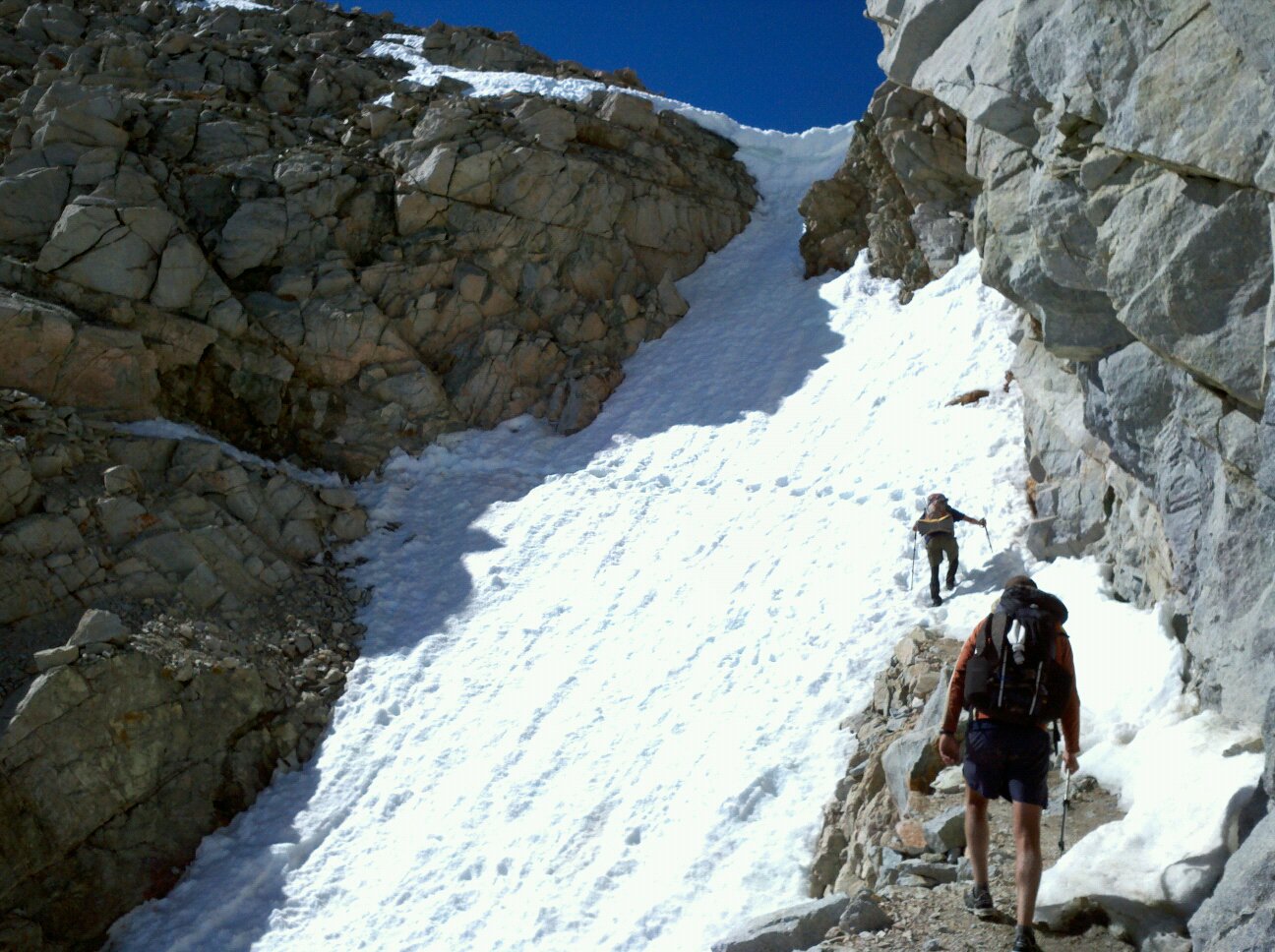

After catching a ride to Independence from Uber-Bitch (actually a really nice woman) and Bristlecone (so named because he's the oldest living thing on the trail), two trail angels who had camped out at Onion Valley Campground to give hikers rides to town (thus saving ~16 miles of road walking), we took a bus to Bishop since it was the nearest town with a full-service grocery store, outfitter, etc. It wasn't a very restful zero-day, but at least I was able to find my trail running shoes (La Sportiva Wildcats) at the outfitter and mail my hiking boots home. I figured that if I was going to have soaking wet feet the whole time anyways, I might as well have a shoe that doesn't hold water like a bucket. With six days of food and a bit of rest, we promptly returned to the trail with Mammoth as our next destination...
Subscribe to:
Posts (Atom)